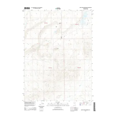
2014 Map of Sheep Creek Reservoir
USGS Topo · Published 2014About this map
Sheep Creek Reservoir and the smaller Poker Flat Reservoir anchor this high-desert landscape in Elko County, illustrating the critical role of water management in Nevada's northeastern ranching and rangeland districts. The terrain is defined by a network of seasonal drainages, including Spring Cr, Sheep Cr, and Indian Cr, which cut through the complex topography of the high plateau. Notable landmarks like Sugarloaf Hill and Horseshoe Bend serve as natural orientation points in an area largely characterized by broad flats and winding creek beds. The presence of Poker Flat Gate and the Bia-202 road suggests the importance of livestock grazing and access to regional tribal lands, providing a clear picture of the land-use patterns that have persisted in this corner of the state into the early twenty-first century.
Find a feature on this map
16 named features on this map. Tap any name to fly to it.
Don’t see what you’re looking for? This feature index may not catch every label — zoom into the map to look around manually.
Map Details
Editions of this 2014 Sheep Creek Reservoir Map
This is the sole edition of this map. No revisions or reprints were ever made.
Other maps of this area

1939 · Owyhee
USGS Topo · 1:62,500

1942 · Owyhee
USGS Topo · 1:62,500

1955 · McDermitt
USGS Topo · 1:250,000

1956 · Bull Run
USGS Topo · 1:62,500

1959 · McDermitt
USGS Topo · 1:250,000

1964 · Hat Peak
USGS Topo · 1:62,500

1964 · Wilson Reservoir
USGS Topo · 1:62,500
1971 · The Point
USGS Topo · 1:24,000
1971 · Dry Creek Reservoir
USGS Topo · 1:24,000

1982 · Bull Run Mts
USGS Topo · 1:100,000