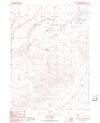
1987 Map of Sheep Creek Reservoir
USGS Topo · Published 1987About this map
The Duck Valley Indian Reservation dominates the northern reaches of this Elko County landscape, where the high desert terrain is shaped by the winding course of Sheep Creek. This 1987 provisional survey documents a transition between the rugged heights of Sugarloaf Hill and the flat, water-managed basins of Poker Flat and its associated Poker Flat Reservoir. The northeastern corner is anchored by the Sheep Creek Reservoir, featuring a dedicated Picnic Area, suggesting its role as a local recreational destination in an otherwise sparse and arid environment. Evidence of industrial activity is limited but present at a Quarry in the southern sector near Indian Creek. The map provides a clear picture of the water distribution and drainage patterns of the era, marking numerous Springs and the seasonal path of Dry Creek as it cuts through the sagebrush-covered hills.
Find a feature on this map
15 named features on this map. Tap any name to fly to it.
Don’t see what you’re looking for? This feature index may not catch every label — zoom into the map to look around manually.
Map Details
Editions of this 1987 Sheep Creek Reservoir Map
This is the sole edition of this map. No revisions or reprints were ever made.
Other maps of this area

1939 · Owyhee
USGS Topo · 1:62,500

1942 · Owyhee
USGS Topo · 1:62,500

1955 · McDermitt
USGS Topo · 1:250,000

1956 · Bull Run
USGS Topo · 1:62,500

1959 · McDermitt
USGS Topo · 1:250,000

1964 · Hat Peak
USGS Topo · 1:62,500

1964 · Wilson Reservoir
USGS Topo · 1:62,500
1971 · The Point
USGS Topo · 1:24,000
1971 · Dry Creek Reservoir
USGS Topo · 1:24,000

1982 · Bull Run Mts
USGS Topo · 1:100,000