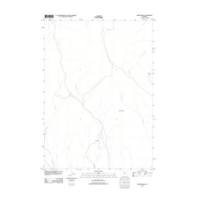
2012 Map of Sheep Ridge
USGS Topo · Published 2012About this map
Sheep Ridge dominates this high-altitude landscape in Fremont County, where a network of seasonal drainages carves through the open range. The map documents a sparse, working landscape defined by the Harris Ranch and its connection to the outside via Harris Rd. The drainage patterns here are complex, featuring the upper reaches of W Fork Sheep Cr and E Fork Sheep Cr, alongside several other named tributaries like Shotgun Cr and Deer Cr. To the northeast, the terrain levels out at Mud Flat near the headwaters of N Fork Mud Cr. This 2012 survey illustrates the enduring nature of Wyoming's ranching country, where settlement remains concentrated at established homesteads while names like Red Cr and Dry Cottonwood Cr signify the vital but intermittent water sources that dictate movement across the ridge.
Find a feature on this map
12 named features on this map. Tap any name to fly to it.
Don’t see what you’re looking for? This feature index may not catch every label — zoom into the map to look around manually.
Map Details
Editions of this 2012 Sheep Ridge Map
This is the sole edition of this map. No revisions or reprints were ever made.
Other maps of this area

1950 · Shotgun Butte
USGS Topo · 1:24,000

1951 · Eagle Point
USGS Topo · 1:24,000

1951 · Jenkins Mountain
USGS Topo · 1:24,000

1952 · Kates Basin
USGS Topo · 1:24,000

1952 · Sheep Ridge
USGS Topo · 1:24,000

1952 · Bargee
USGS Topo · 1:24,000

1955 · Thermopolis
USGS Topo · 1:250,000
1957 · Jenkins Mountain
USGS Topo · 1:24,000

1958 · Thermopolis
USGS Topo · 1:250,000

1962 · Thermopolis
USGS Topo · 1:250,000