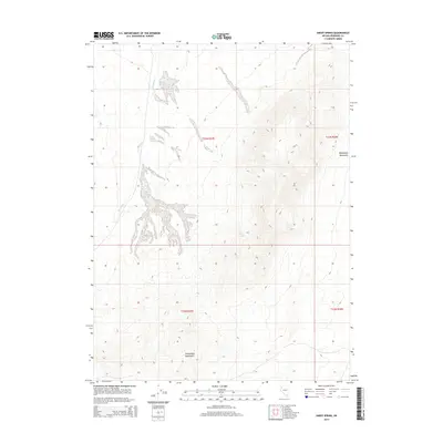
2014 Map of Sheep Spring
USGS Topo · Published 2014About this map
Sheephead Mountains dominate this high-desert terrain in Nevada's Great Basin, as documented in 2014. The landscape is defined by its arid hydrology and complex geologic formations, most notably the seasonal flow of Lava Beds Cr which cuts through the volcanic basin floors. A singular water source, Sheep Spring, provides a vital point of interest for those tracking historical land use and animal migration patterns in this remote region. This map illustrates the intersection of Public Land Survey System township and range lines, such as t33n r27e and t32n r28e, over a landscape where reliable water and topography dictated the routes of early travelers and surveyors alike.
Find a feature on this map
7 named features on this map. Tap any name to fly to it.
Don’t see what you’re looking for? This feature index may not catch every label — zoom into the map to look around manually.
Map Details
Editions of this 2014 Sheep Spring Map
This is the sole edition of this map. No revisions or reprints were ever made.
Other maps of this area

1886 · Granite Range
USGS Topo · 1:250,000

1894 · Granite Range
USGS Topo · 1:250,000

1931 · Lovelock
USGS Topo · 1:250,000

1935 · Lovelock
USGS Topo · 1:250,000

1955 · Lovelock
USGS Topo · 1:250,000

1959 · Lovelock
USGS Topo · 1:250,000

1980 · Eagle Rock Spring
USGS Topo · 1:24,000
1980 · Trego Hot Spring
USGS Topo · 1:24,000

1980 · Dry Mountain
USGS Topo · 1:24,000
1981 · Sheep Spring
USGS Topo · 1:24,000