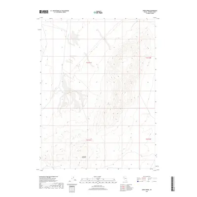
2018 Map of Sheep Spring
USGS Topo · Published 2018About this map
Sheephead Mountains dominate the southern portion of this high-desert landscape in Pershing County, where the terrain rises sharply from the surrounding basins. This 2018 survey documents a largely undeveloped region defined by complex natural drainage patterns and the isolated water sources essential for survival in this arid environment. The intermittent course of Lava Beds Cr cuts through the western sections, while the namesake Sheep Spring provides a vital point of interest on the eastern slopes of the mountain range. This map reveals a rugged land partitioned by the Public Land Survey System, including t33n r27e, which outlines the cadastral history of Nevada's remote interior. The absence of modern roads or settlements highlights the topographic continuity of this high-altitude terrain, preserving the same physical characteristics encountered by early surveyors and ranching interests in the Great Basin.
Find a feature on this map
7 named features on this map. Tap any name to fly to it.
Don’t see what you’re looking for? This feature index may not catch every label — zoom into the map to look around manually.
Map Details
Editions of this 2018 Sheep Spring Map
This is the sole edition of this map. No revisions or reprints were ever made.
Other maps of this area

1886 · Granite Range
USGS Topo · 1:250,000

1894 · Granite Range
USGS Topo · 1:250,000

1931 · Lovelock
USGS Topo · 1:250,000

1935 · Lovelock
USGS Topo · 1:250,000

1955 · Lovelock
USGS Topo · 1:250,000

1959 · Lovelock
USGS Topo · 1:250,000

1980 · Eagle Rock Spring
USGS Topo · 1:24,000
1980 · Trego Hot Spring
USGS Topo · 1:24,000

1980 · Dry Mountain
USGS Topo · 1:24,000
1981 · Sheep Spring
USGS Topo · 1:24,000