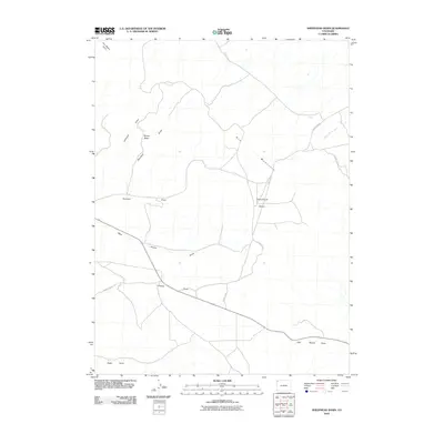
2010 Map of Sheephead Basin
USGS Topo · Published 2010About this map
Sheephead Basin and the adjacent Spicer Basin define this drainage-rich landscape in northwestern Colorado. The terrain is characterized by an intricate network of seasonal watercourses, including Lefthand Draw, Marshall Draw, and Hartman Draw, which carve through the high-desert plateau. In the northwest corner, the distinctive formation of The Bears Ears stands as a prominent landmark. The area is intersected by several county routes, notably County Rd 12 and County Rd 48, providing access to the remote backcountry. To the east, the map tracks the path of South Sand Wash and the convergence of Boone Draw and East Boone Draw. This 2010 survey illustrates the modern configuration of access roads and natural landforms in a region defined by its sparse settlement and complex hydrology.
Find a feature on this map
15 named features on this map. Tap any name to fly to it.
Don’t see what you’re looking for? This feature index may not catch every label — zoom into the map to look around manually.
Map Details
Editions of this 2010 Sheephead Basin Map
This is the sole edition of this map. No revisions or reprints were ever made.
Other maps of this area

1954 · Vernal
USGS Topo · 1:250,000

1958 · Vernal
USGS Topo · 1:250,000

1960 · Vernal
USGS Topo · 1:250,000

1960 · Lone Mountain
USGS Topo · 1:62,500

1966 · G Spring
USGS Topo · 1:24,000
1966 · Limestone Hill
USGS Topo · 1:24,000

1966 · Irish Canyon
USGS Topo · 1:24,000

1966 · Sheephead Basin
USGS Topo · 1:24,000
1966 · Greystone
USGS Topo · 1:24,000
1966 · Vermillion Mesa
USGS Topo · 1:24,000