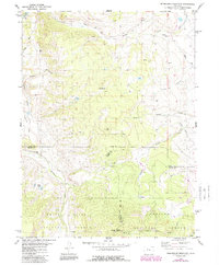
1980 Map of Sheephorn Mountain
USGS Topo · Published 1988About this map
Sheephorn Mountain stands as the central landmark of this high-elevation landscape where the borders of Grand, Eagle, and Summit counties converge. The 1980s terrain is characterized by a network of drainage systems, including Sheephorn Creek, Beaver Creek, and the headwaters of the North Fork Deep Creek. Evidence of local history and small-scale land use appears in the Sheephorn Cem and scattered sites like the Gravel Pit and various unnamed quarries. Much of the southern portion of the map is protected within the White River National Forest and Arapaho National Forest, where the topography rises toward Dice Hill and Sheep Mountain. The map shows a transition from the narrow Corduroy Canyon and Hartman Gulch to higher alpine lakes, such as Gutzler Lakes, accessible via a series of Jeep trails that navigate the steep divides.
Find a feature on this map
27 named features on this map. Tap any name to fly to it.
Don’t see what you’re looking for? This feature index may not catch every label — zoom into the map to look around manually.
Map Details
Editions of this 1980 Sheephorn Mountain Map
3 editions found
Other maps of this area

1933 · Mt. Powell
USGS Topo · 1:48,000

1940 · Mount Powell
USGS Topo · 1:62,500

1954 · Craig
USGS Topo · 1:250,000

1956 · Kremmling
USGS Topo · 1:62,500

1956 · Gore Pass
USGS Topo · 1:62,500

1957 · Craig
USGS Topo · 1:250,000

1957 · Leadville
USGS Topo · 1:250,000

1958 · Craig
USGS Topo · 1:250,000

1959 · Leadville
USGS Topo · 1:250,000

1960 · Leadville
USGS Topo · 1:250,000