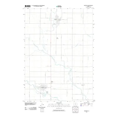
2010 Map of Sheffield
USGS Topo · Published 2010About this map
Sheffield and Rockwell anchor this northern Iowa landscape, where the Jefferson Highway corridor meets a complex network of prairie waterways. The transition between Franklin and Cerro Gordo counties is clearly marked by Cerro Gordo St, reflecting the rigid grid of the Public Land Survey System that dictates the region's agricultural layout. Local history is anchored at several rural burial grounds, including Sacred Heart Cemetery north of the county line and Hillside Cemetery just north of Sheffield. The terrain is defined by the winding paths of the West Fork Cedar River and its tributaries, such as Bailey Creek and Lillibridge Creek, which cut through the rectilinear farm plots. The location of the Rockwell Post Office and Sheffield Post Office highlight the continued importance of these towns as centers for the surrounding farming community.
Find a feature on this map
38 named features on this map. Tap any name to fly to it.
Don’t see what you’re looking for? This feature index may not catch every label — zoom into the map to look around manually.
Map Details
Editions of this 2010 Sheffield Map
This is the sole edition of this map. No revisions or reprints were ever made.
Other maps of this area

1954 · Mason City
USGS Topo · 1:250,000

1954 · Waterloo
USGS Topo · 1:250,000

1955 · Waterloo
USGS Topo · 1:250,000

1957 · Mason City
USGS Topo · 1:250,000

1958 · Mason City
USGS Topo · 1:250,000

1959 · Mason City
USGS Topo · 1:62,500

1959 · Mason City SE
USGS Topo · 1:24,000

1959 · Hanford
USGS Topo · 1:24,000

1972 · Hansell
USGS Topo · 1:24,000
1972 · Dougherty
USGS Topo · 1:24,000