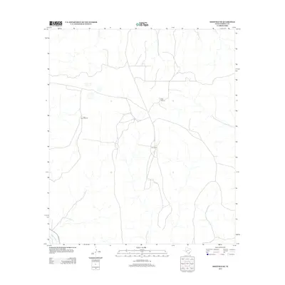
2012 Map of Sheffield SE
USGS Topo · Published 2012About this map
Independence Cr cuts through the southwestern corner of this West Texas landscape, a rare perennial feature in the arid environment of Terrell County. This 2012 survey illustrates the continued reliance on scattered water infrastructure for ranching operations, marked by the presence of the East Martin Windmill and the Farm Tank Windmill. These landmarks serve as vital nodes in a sparse network of unpaved roads and trails that connect isolated outposts like the Allison Ranch. The topography is defined by the drainage patterns that feed toward the creek, showcasing the rugged isolation typical of the Trans-Pecos region where human settlement is clustered around reliable water sources and established ranching headquarters.
Find a feature on this map
4 named features on this map. Tap any name to fly to it.
Don’t see what you’re looking for? This feature index may not catch every label — zoom into the map to look around manually.
Map Details
Editions of this 2012 Sheffield SE Map
This is the sole edition of this map. No revisions or reprints were ever made.
Other maps of this area

1929 · Sheffield
USGS Topo · 1:125,000

1954 · Sonora
USGS Topo · 1:250,000

1958 · Sonora
USGS Topo · 1:250,000

1967 · Sheffield NW
USGS Topo · 1:24,000

1967 · Horsehead Canyon
USGS Topo · 1:24,000

1967 · Fort Lancaster
USGS Topo · 1:24,000

1967 · Sheffield SE
USGS Topo · 1:24,000

1967 · Dead Man Canyon
USGS Topo · 1:24,000
1967 · Sheffield
USGS Topo · 1:24,000
1973 · Sixshooter Canyon
USGS Topo · 1:24,000