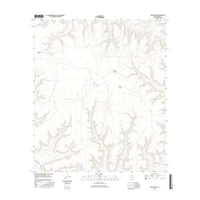
2016 Map of Sheffield SE
USGS Topo · Published 2016About this map
Reagan Canyon and North Canyon dominate the topography of this portion of Terrell County, showcasing the dramatic drainage patterns typical of the Trans-Pecos region. In the south, Independence Cr flows toward the Rio Grande drainage, while Harkey Draw marks the upper reaches of the map's complex network of ephemeral waterways and steep relief. This 2016 survey provides a precise look at the area's limited infrastructure, primarily centered around Ranch Rd 1217 in the southwest corner. For those interested in the remote West Texas landscape, the map reveals how sparse human development follows the natural contours and accessible gaps between these deep limestone canyons.
Find a feature on this map
5 named features on this map. Tap any name to fly to it.
Don’t see what you’re looking for? This feature index may not catch every label — zoom into the map to look around manually.
Map Details
Editions of this 2016 Sheffield SE Map
This is the sole edition of this map. No revisions or reprints were ever made.
Other maps of this area

1929 · Sheffield
USGS Topo · 1:125,000

1954 · Sonora
USGS Topo · 1:250,000

1958 · Sonora
USGS Topo · 1:250,000

1967 · Sheffield NW
USGS Topo · 1:24,000

1967 · Horsehead Canyon
USGS Topo · 1:24,000

1967 · Fort Lancaster
USGS Topo · 1:24,000

1967 · Sheffield SE
USGS Topo · 1:24,000

1967 · Dead Man Canyon
USGS Topo · 1:24,000
1967 · Sheffield
USGS Topo · 1:24,000
1973 · Sixshooter Canyon
USGS Topo · 1:24,000