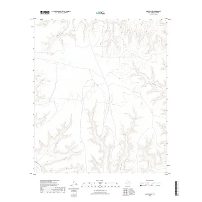
2019 Map of Sheffield SE
USGS Topo · Published 2019About this map
Independence Cr cuts across the southwestern corner of this Terrell County landscape, marking one of the few watercourses in an area defined by steep drainage patterns. The terrain is characterized by a series of significant erosional features, including the winding path of Harkey Draw in the north and the deep incisions of Reagan Canyon and North Canyon to the east and south. This 2019 survey illustrates a largely uninhabited portion of the Trans-Pecos, where human infrastructure is limited to the corridor of Ranch Rd 1217. The map reveals the intricate natural topography of the Texas ranch lands, showing the subtle network of unimproved roads and fences that negotiate the complex system of ridges and valleys characteristic of this arid region.
Find a feature on this map
5 named features on this map. Tap any name to fly to it.
Don’t see what you’re looking for? This feature index may not catch every label — zoom into the map to look around manually.
Map Details
Editions of this 2019 Sheffield SE Map
This is the sole edition of this map. No revisions or reprints were ever made.
Other maps of this area

1929 · Sheffield
USGS Topo · 1:125,000

1954 · Sonora
USGS Topo · 1:250,000

1958 · Sonora
USGS Topo · 1:250,000

1967 · Sheffield NW
USGS Topo · 1:24,000

1967 · Horsehead Canyon
USGS Topo · 1:24,000

1967 · Fort Lancaster
USGS Topo · 1:24,000

1967 · Sheffield SE
USGS Topo · 1:24,000

1967 · Dead Man Canyon
USGS Topo · 1:24,000
1967 · Sheffield
USGS Topo · 1:24,000
1973 · Sixshooter Canyon
USGS Topo · 1:24,000