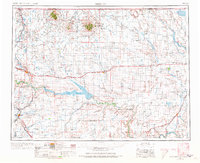
1954 Map of Shelby
USGS Topo · Published 1973About this map
The Sweet Grass Hills rise prominently along the Montana-Alberta border, featuring significant peaks like West Butte and East Butte. This mid-century landscape is defined by the development of the high plains, where the Great Northern railroad corridors fostered a string of settlements including Chester, Joplin, and Rudyard. The presence of numerous Oil and gas wells near Sunburst and Kevin points to the region's industrial heritage in the Kevin-Sunburst oil field. Large-scale water management projects are visible through the Tiber Reservoir on the Marias River and the Fresno Reservoir on the Milk River. To the east, the Rocky Boys Indian Reservation occupies the edge of the Lonesome Prairie, while the southern reaches follow the winding path of the Missouri River near Virgelle.
Find a feature on this map
95 named features on this map. Tap any name to fly to it.
Don’t see what you’re looking for? This feature index may not catch every label — zoom into the map to look around manually.
Map Details
Editions of this 1954 Shelby Map
3 editions found

Other maps of this area

1886 · Great Falls
USGS Topo · 1:250,000

1890 · Fort Benton
USGS Topo · 1:250,000

1892 · Fort Benton
USGS Topo · 1:250,000

1897 · Fort Benton
USGS Topo · 1:250,000

1904 · Assinniboine
USGS Topo · 1:62,500

1904 · Boxelder
USGS Topo · 1:62,500

1906 · Kremlin
USGS Topo · 1:62,500

1906 · Lonesome
USGS Topo · 1:62,500

1906 · Boxelder
USGS Topo · 1:62,500

1909 · Cut Bank
USGS Topo · 1:125,000