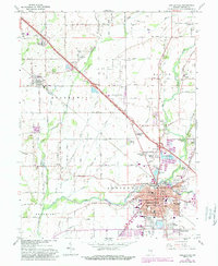
1962 Map of Shelbyville
USGS Topo · Published 1988About this map
Shelbyville sits at the confluence of the Big Blue River and Brandywine Creek, serving as a regional hub for central Indiana. In the early 1960s, the town's expansion is evident through emerging residential areas like Knighthood Grove, Riley Village, and Wellington Heights. The landscape reflects a mix of suburban growth and industrial utility, with the New York Central railroad and new highway developments like Interchange 109 facilitating local travel. Beyond the city center, the survey captures traditional landmarks including Marion Cem and the Swain Memorial Forest Ch. The presence of several gravel operations, such as Burnside Pit and various Gravel Pits, underscores the importance of local mineral extraction to the area's development during this era of mid-century infrastructure expansion.
Find a feature on this map
60 named features on this map. Tap any name to fly to it.
Don’t see what you’re looking for? This feature index may not catch every label — zoom into the map to look around manually.
Map Details
Editions of this 1962 Shelbyville Map
4 editions found
Other maps of this area

1942 · Columbus
USGS Topo · 1:125,000

1948 · Lewis Creek
USGS Topo · 1:24,000

1948 · Marietta
USGS Topo · 1:24,000

1950 · Edinburg
USGS Topo · 1:62,500

1952 · Fountaintown
USGS Topo · 1:24,000

1953 · Shelbyville
USGS Topo · 1:24,000

1953 · Acton
USGS Topo · 1:24,000

1953 · Boggstown
USGS Topo · 1:24,000

1953 · Cincinnati
USGS Topo · 1:250,000

1956 · Morristown
USGS Topo · 1:24,000