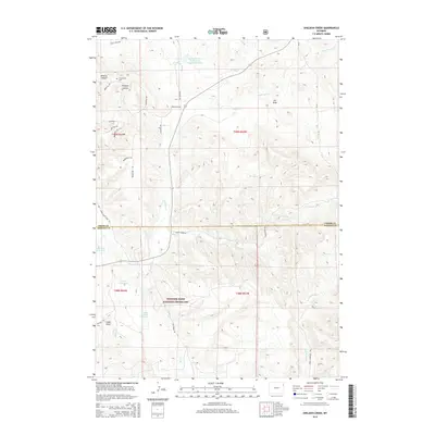
2015 Map of Sheldon Creek
USGS Topo · Published 2015About this map
Thunder Basin National Grassland dominates the southern half of this 2015 study, illustrating a landscape defined by significant water management and ranching infrastructure. Numerous reservoirs like Jeff Davis Reservoir, Cedar Reservoir, and the Russell Storage Reservoir are scattered across the terrain, connected by seasonal drainages such as Mason Cr and Sheldon Cr. The names of the local thoroughfares—Stock Trail Dr, Gunsmoke Trl, Broad Axe Rd, and Derringer Trl—heavily reflect the region's western heritage and livestock history. To the north, Wildcat Canyon and Philpott Canyon provide topographical relief near Greenwood Cem, while the Spring Branch Development Company Reservoir suggests commercial water development in the Inyan Kara Cr basin.
Find a feature on this map
38 named features on this map. Tap any name to fly to it.
Don’t see what you’re looking for? This feature index may not catch every label — zoom into the map to look around manually.
Map Details
Editions of this 2015 Sheldon Creek Map
This is the sole edition of this map. No revisions or reprints were ever made.
Other maps of this area

1898 · Sundance
USGS Topo · 1:125,000

1902 · Sundance
USGS Topo · 1:125,000

1918 · Moorcroft
USGS Topo · 1:125,000

1954 · Gillette
USGS Topo · 1:250,000

1955 · Gillette
USGS Topo · 1:250,000

1957 · Nefsy Divide
USGS Topo · 1:62,500

1957 · Upton
USGS Topo · 1:62,500

1958 · Gillette
USGS Topo · 1:250,000
1958 · Inyan Kara Mountain
USGS Topo · 1:62,500

1958 · Sundance
USGS Topo · 1:62,500