
1965 Map of Sheldon
USGS Topo · Published 1966About this map
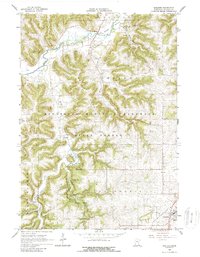
The South Fork Root River winds through the northern landscape of Houston County, where the driftless area's intricate drainage patterns are strikingly visible. This mid-1960s environment is defined by the steep coulees and ridges of the Minnesota Memorial Hardwood State Forest. Deep within the valley of Beaver Creek, the Beaver Creek Valley State Park preserves a pocket of recreational land complete with a Campground and Picnic Area.
Find a feature on this map
28 named features on this map. Tap any name to fly to it.
Don’t see what you’re looking for? This feature index may not catch every label — zoom into the map to look around manually.
Map Details
Editions of this 1965 Sheldon Map
2 editions found
Other maps of this area

1930 · La Crescent
USGS Topo · 1:62,500

1956 · Brownsville
USGS Topo · 1:62,500

1956 · La Crescent
USGS Topo · 1:62,500

1958 · Houston
USGS Topo · 1:62,500

1958 · La Crosse
USGS Topo · 1:250,000

1961 · La Crosse
USGS Topo · 1:250,000

1965 · La Crosse
USGS Topo · 1:250,000

1965 · Wilmington
USGS Topo · 1:24,000

1965 · Spring Grove
USGS Topo · 1:24,000

1965 · Yucatan
USGS Topo · 1:24,000