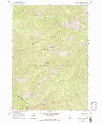
1963 Map of Sheldon Peak
USGS Topo · Published 1964About this map
Sheldon Peak and the high ridges of the Challis National Forest dominate this 1963 survey of the remote Idaho interior. The landscape is defined by the steep drainages of the South Fork Camas Creek and its many tributaries, including Hot Creek and Sheldon Creek. This high-elevation terrain, mapped during the early 1960s, reveals a primitive backcountry infrastructure centered around forest management and natural water sources. Near the boundary of Lemhi and Custer Counties, the Warm Spring Ranger Cabin serves as a lone outpost for wilderness monitoring. The abundance of geothermal and alpine features is evident in labels like Shower Bath Springs, Warm Spring Creek, and Fly Creek Point, illustrating how water and geology shaped the human footprint in this corner of the Salmon River mountains.
Find a feature on this map
21 named features on this map. Tap any name to fly to it.
Don’t see what you’re looking for? This feature index may not catch every label — zoom into the map to look around manually.
Map Details
Editions of this 1963 Sheldon Peak Map
2 editions found
Other maps of this area

1930 · Casto
USGS Topo · 1:125,000

1956 · Twin Peaks
USGS Topo · 1:62,500

1957 · Challis
USGS Topo · 1:250,000

1960 · Challis
USGS Topo · 1:250,000

1963 · Challis
USGS Topo · 1:250,000

1963 · Challis Creek Lakes
USGS Topo · 1:24,000

1963 · Meyers Cove
USGS Topo · 1:24,000

1963 · Rock Creek
USGS Topo · 1:24,000
1963 · Sherman Peak
USGS Topo · 1:24,000
1963 · Sleeping Deer Mountain
USGS Topo · 1:24,000