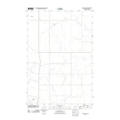
2011 Map of Shell Butte
USGS Topo · Published 2011About this map
Shell Butte rises as a prominent landmark in this corner of Fallon County, overlooking a landscape defined by an intricate network of drainages and early 21st-century water management. The terrain is etched by the meandering courses of Beaver Creek and the Fork of Beaver Creek, which dominate the eastern and central portions of the quadrangle. Agricultural infrastructure is evident through features like Stark Dam and Halmans Number 1 Dam, indicating the importance of water catchment in this semi-arid region. A systematic grid of local transit is established by thoroughfares such as Road 678 and Road 619, which provide access to the remote sections of the county. The map also captures the headwaters of Cannonball Creek and Cabin Creek, reflecting the complex hydrologic patterns that have shaped the ranching and land-use history of this Montana prairie.
Find a feature on this map
13 named features on this map. Tap any name to fly to it.
Don’t see what you’re looking for? This feature index may not catch every label — zoom into the map to look around manually.
Map Details
Editions of this 2011 Shell Butte Map
This is the sole edition of this map. No revisions or reprints were ever made.
Other maps of this area

1953 · Miles City
USGS Topo · 1:250,000

1957 · Miles City
USGS Topo · 1:250,000

1958 · Miles City
USGS Topo · 1:250,000

1981 · Baker
USGS Topo · 1:100,000

1981 · Baker NE
USGS Topo · 1:24,000
1981 · Morris Butte
USGS Topo · 1:24,000

1981 · Cap Rock
USGS Topo · 1:24,000
1981 · Badland Draw
USGS Topo · 1:24,000
1981 · Shell Butte
USGS Topo · 1:24,000

1981 · Carlyle
USGS Topo · 1:24,000