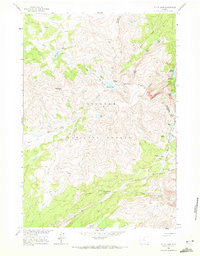
1960 Map of Shell Lake
USGS Topo · Published 1972About this map
Teepee Pole Flats and the high basins of the Big Horn National Forest define this 1960 field-checked survey. The landscape is characterized by a complex network of alpine water bodies, including Shell Lake, the clustered Lakes of the Rough, and Emerald Lake. These high-altitude features are connected by established backcountry routes such as the Edelman Trail and Solitude Trail, which navigate the steep divides of the Big Horn and Johnson County line.
Find a feature on this map
38 named features on this map. Tap any name to fly to it.
Don’t see what you’re looking for? This feature index may not catch every label — zoom into the map to look around manually.
Map Details
Editions of this 1960 Shell Lake Map
4 editions found
Other maps of this area

1895 · Dayton
USGS Topo · 1:125,000

1899 · Cloud peak
USGS Topo · 1:125,000

1901 · Cloud Peak
USGS Topo · 1:125,000

1901 · Dayton
USGS Topo · 1:125,000

1955 · Sheridan
USGS Topo · 1:250,000

1958 · Sheridan
USGS Topo · 1:250,000

1960 · Shell Lake
USGS Topo · 1:24,000

1960 · Lake Solitude
USGS Topo · 1:24,000

1960 · Spanish Point
USGS Topo · 1:24,000

1962 · Sheridan
USGS Topo · 1:250,000