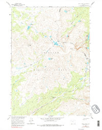
1960 Map of Shell Lake
USGS Topo · Published 1979About this map
Big Horn National Forest encompasses this high-altitude landscape, where numerous glacial lakes and alpine passes define the drainage patterns of northern Wyoming. The 1960 field checks recorded a network of primitive transportation routes, including the Edelman Trail and Solitude Trail, which provided access to remote backcountry basins. Several high-elevation crossings like Dutch Oven Pass and Edelman Pass connect the watersheds of Shell Creek and Edelman Creek.
Find a feature on this map
37 named features on this map. Tap any name to fly to it.
Don’t see what you’re looking for? This feature index may not catch every label — zoom into the map to look around manually.
Map Details
Editions of this 1960 Shell Lake Map
4 editions found
Other maps of this area

1895 · Dayton
USGS Topo · 1:125,000

1899 · Cloud peak
USGS Topo · 1:125,000

1901 · Cloud Peak
USGS Topo · 1:125,000

1901 · Dayton
USGS Topo · 1:125,000

1955 · Sheridan
USGS Topo · 1:250,000

1958 · Sheridan
USGS Topo · 1:250,000

1960 · Shell Lake
USGS Topo · 1:24,000

1960 · Lake Solitude
USGS Topo · 1:24,000

1960 · Spanish Point
USGS Topo · 1:24,000

1962 · Sheridan
USGS Topo · 1:250,000