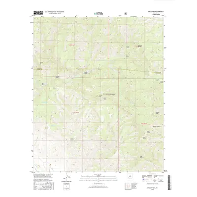
2017 Map of Shelley Peak
USGS Topo · Published 2017About this map
Shelley Peak and the high ridges of the Mogollon Mountains dominate this high-elevation landscape within the Gila National Forest. The topography is defined by a dense network of drainage systems, including the complex forks of Mogollon Creek, which has carved dramatic relief such as Woodrow Canyon and Skeleton Canyon. This area, straddling the boundary of Catron and Grant counties, shows very limited human infrastructure, focusing instead on water management features essential for wilderness or ranching utility. Small-scale water sources like Deadman Tank and Seventyfour Mountain Tank are scattered throughout the peaks, while named landmarks such as Lookout Mountain provide orientation in the backcountry. The map also captures the natural hydrology of the region, from the secluded Buds Hole to the flow of Trail Creek.
Find a feature on this map
31 named features on this map. Tap any name to fly to it.
Don’t see what you’re looking for? This feature index may not catch every label — zoom into the map to look around manually.
Map Details
Editions of this 2017 Shelley Peak Map
This is the sole edition of this map. No revisions or reprints were ever made.
Other maps of this area

1910 · Mogollon
USGS Topo · 1:125,000

1911 · Alum Mountain
USGS Topo · 1:125,000

1912 · Mogollon
USGS Topo · 1:125,000

1913 · Alum Mountain
USGS Topo · 1:125,000

1954 · Clifton
USGS Topo · 1:250,000

1957 · Clifton
USGS Topo · 1:250,000

1958 · Clifton
USGS Topo · 1:250,000

1962 · Clifton
USGS Topo · 1:250,000
1965 · Canteen Canyon
USGS Topo · 1:24,000
1965 · Diablo Range
USGS Topo · 1:24,000