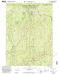
1997 Map of Shelly Creek Ridge
USGS Topo · Published 2001About this map
The Smith River and its complex network of forks dominate this remote corner of Northern California, where the Smith River National Recreation Area meets the Siskiyou National Forest. Historically, this landscape was defined by its access routes and mineral potential. The Old Gasquet Toll Road and the Wimer Road trace the difficult paths taken by early travelers across the state line between Oregon and California. Mining activity is evident through the presence of the Holiday Mine and various prospects scattered across the high terrain of Shelly Creek Ridge. Small settlements and landmarks like Baker Flat, Idlewild, and the Monumental (Site) provide evidence of human presence in the river valleys, while Washington Peak and High Dome anchor the surrounding Siskiyou Mountains.
Find a feature on this map
52 named features on this map. Tap any name to fly to it.
Don’t see what you’re looking for? This feature index may not catch every label — zoom into the map to look around manually.
Map Details
Editions of this 1997 Shelly Creek Ridge Map
This is the sole edition of this map. No revisions or reprints were ever made.
Other maps of this area

1917 · Kerby
USGS Topo · 1:125,000

1918 · Kerby
USGS Topo · 1:125,000

1922 · Preston Peak
USGS Topo · 1:125,000

1945 · Kerby
USGS Topo · 1:125,000

1945 · Gasquet
USGS Topo · 1:62,500

1948 · Weed
USGS Topo · 1:250,000

1950 · Weed
USGS Topo · 1:250,000

1951 · Gasquet
USGS Topo · 1:62,500

1954 · Cave Junction
USGS Topo · 1:62,500

1954 · Chetco Peak
USGS Topo · 1:62,500