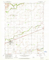
1962 Map of Shelton
USGS Topo · Published 1964About this map
The Union Pacific railroad corridor serves as the primary artery through this Nebraska landscape, anchoring the town of Shelton and the nearby Platte Valley Academy. This 1962 planetable survey reveals a rural society organized around a dense network of one-room schoolhouses, including School No 10, School No 32, and School No 46, suggesting a decentralized educational system still in transition. The terrain is defined by the braided hydrology of the North Channel Platte River and the meandering paths of Silver Creek and Wood River. Agricultural and industrial land use is evident in the scattered Sandpit and Gravel Pit operations, while local genealogy is grounded in the presence of the Shelton Cem and St Mary Cem. The boundary between Buffalo Co and Hall Co cuts through the western section, illustrating the political division of these fertile river bottoms.
Find a feature on this map
26 named features on this map. Tap any name to fly to it.
Don’t see what you’re looking for? This feature index may not catch every label — zoom into the map to look around manually.
Map Details
Editions of this 1962 Shelton Map
2 editions found
Other maps of this area

1894 · Kenesaw
USGS Topo · 1:62,500

1894 · Minden
USGS Topo · 1:62,500

1895 · Wood River
USGS Topo · 1:62,500

1896 · Wood River
USGS Topo · 1:125,000

1955 · Grand Island
USGS Topo · 1:250,000

1957 · Grand Island
USGS Topo · 1:250,000

1958 · Grand Island
USGS Topo · 1:250,000

1962 · Denman
USGS Topo · 1:24,000

1962 · Prosser
USGS Topo · 1:24,000
1962 · Shelton NE
USGS Topo · 1:24,000