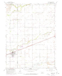
1962 Map of Shelton
USGS Topo · Published 1977About this map
The town of Shelton sits at the heart of this central Nebraska landscape, anchored by the Union Pacific railroad and surrounded by a network of braided river channels and prairie creeks. This mid-century survey illustrates the rural infrastructure of Buffalo and Hall Counties, where the water of the Platte River and its North Channel dictates the layout of the land. The presence of the Platte Valley Academy and several numbered schoolhouses, such as School No 33 and School No 5, reflects a well-established educational network serving the farming community.
Find a feature on this map
25 named features on this map. Tap any name to fly to it.
Don’t see what you’re looking for? This feature index may not catch every label — zoom into the map to look around manually.
Map Details
Editions of this 1962 Shelton Map
2 editions found
Other maps of this area

1894 · Kenesaw
USGS Topo · 1:62,500

1894 · Minden
USGS Topo · 1:62,500

1895 · Wood River
USGS Topo · 1:62,500

1896 · Wood River
USGS Topo · 1:125,000

1955 · Grand Island
USGS Topo · 1:250,000

1957 · Grand Island
USGS Topo · 1:250,000

1958 · Grand Island
USGS Topo · 1:250,000

1962 · Denman
USGS Topo · 1:24,000

1962 · Prosser
USGS Topo · 1:24,000
1962 · Shelton NE
USGS Topo · 1:24,000