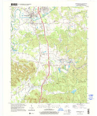
1998 Map of Shepherdsville
USGS Topo · Published 2001About this map
Shepherdsville sits at the northern edge of this survey, where the Salt River meets Floyds Fork. The landscape south of the river is a study in mid-century transportation and conservation, dominated by the north-south corridor of the L & N RR and the sprawling acreage of the Bernheim Forest Arboretum. Local life is anchored by small communities such as Bardstown Junction and Clermont, with numerous rural institutions like Bowmans Valley Ch and the Roby Sch dotting the countryside. The topography is defined by prominent knobs and deep hollows, including Indian Knob and Guerilla Hollow, which provide a sharp contrast to the developed river valley. Genealogists will find a wealth of family-named landmarks and resting places, from Hall Cem to the Beech Grove Cem near the winding course of Long Lick Run.
Find a feature on this map
64 named features on this map. Tap any name to fly to it.
Don’t see what you’re looking for? This feature index may not catch every label — zoom into the map to look around manually.
Map Details
Editions of this 1998 Shepherdsville Map
This is the sole edition of this map. No revisions or reprints were ever made.
Other maps of this area

1907 · Louisville
USGS Topo · 1:62,500

1909 · Kosmosdale
USGS Topo · 1:48,000

1912 · Kosmosdale
USGS Topo · 1:62,500

1936 · Vine Grove
USGS Topo · 1:62,500

1943 · Vine Grove
USGS Topo · 1:62,500

1946 · Pitts Point
USGS Topo · 1:24,000

1946 · Colesburg
USGS Topo · 1:24,000

1946 · Vine Grove
USGS Topo · 1:62,500

1949 · Cravens
USGS Topo · 1:24,000

1949 · Shepherdsville
USGS Topo · 1:24,000