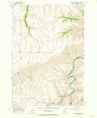
1962 Map of Sherars Bridge
USGS Topo · Published 1964About this map
Sherars Bridge serves as a historic crossing point over the Deschutes River, where the canyon walls drop steeply from the heights of Tygh Ridge. This early 1960s landscape is defined by the sharp contrast between the high wheat lands and the deeply entrenched river valley, which forms the boundary between Wasco and Sherman Counties. The river corridor is a hub of mid-century transportation infrastructure, featuring the Spokane Portland and Seattle and Oregon Trunk railroad lines hugging the water's edge. Evidence of pioneer and rural development is scattered throughout the uplands, from the Warner Cemetery to various springs and the Highline Ditch irrigation works. Smaller settlements like Sherar and the edge of Tygh Valley are documented alongside family-named landmarks and watercourses such as Winter Water Creek and Elder Creek, providing a detailed look at the rural economy of north-central Oregon.
Find a feature on this map
26 named features on this map. Tap any name to fly to it.
Don’t see what you’re looking for? This feature index may not catch every label — zoom into the map to look around manually.
Map Details
Editions of this 1962 Sherars Bridge Map
Other maps of this area

1930 · Dufur
USGS Topo · 1:125,000

1934 · Dufur
USGS Topo · 1:125,000

1953 · The Dalles
USGS Topo · 1:250,000

1956 · The Dalles
USGS Topo · 1:250,000

1957 · The Dalles
USGS Topo · 1:250,000

1962 · Sherars Bridge
USGS Topo · 1:24,000

1962 · Postage Stamp Butte
USGS Topo · 1:24,000

1962 · Summit Ridge
USGS Topo · 1:24,000

1962 · Dufur East
USGS Topo · 1:24,000

1962 · Sinamox
USGS Topo · 1:24,000