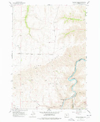
1962 Map of Sherars Bridge
USGS Topo · Published 1978About this map
Sherars Bridge serves as a critical focal point on this map, where the crossing spans the Deschutes River at the boundary of Wasco and Sherman counties. The landscape is dominated by the massive elevation of Tygh Ridge, rising sharply above the river canyon and the eastern edge of Tygh Valley. This 1962 field-checked survey illustrates a high-desert environment defined by vital water management, seen in the winding Tygh Highline Ditch and numerous isolated Springs that supported ranching and transit in this arid corridor.
Find a feature on this map
26 named features on this map. Tap any name to fly to it.
Don’t see what you’re looking for? This feature index may not catch every label — zoom into the map to look around manually.
Map Details
Editions of this 1962 Sherars Bridge Map
Other maps of this area

1930 · Dufur
USGS Topo · 1:125,000

1934 · Dufur
USGS Topo · 1:125,000

1953 · The Dalles
USGS Topo · 1:250,000

1956 · The Dalles
USGS Topo · 1:250,000

1957 · The Dalles
USGS Topo · 1:250,000

1962 · Sherars Bridge
USGS Topo · 1:24,000

1962 · Postage Stamp Butte
USGS Topo · 1:24,000

1962 · Summit Ridge
USGS Topo · 1:24,000

1962 · Dufur East
USGS Topo · 1:24,000

1962 · Sinamox
USGS Topo · 1:24,000