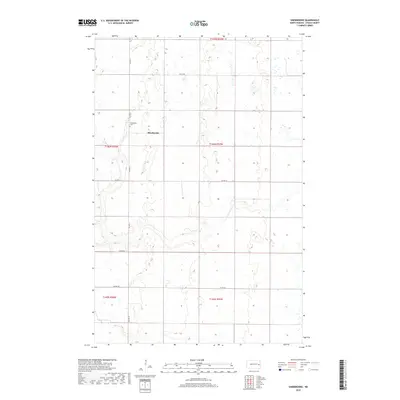
2018 Map of Sherbrooke
USGS Topo · Published 2018About this map
Sherbrooke serves as the quiet center of this Steele County landscape, where the Jeffersonian grid of the Public Land Survey System is laid out across the prairie. The map reveals the township's organization through sections such as t146n r56w and t146n r55w, illustrating the agricultural division of North Dakota. Genealogy researchers will find significant value in the location of the Sherbrooke Cem, situated just west of the primary settlement. The transportation network is defined by a series of rural routes including Co Hwy 6 and Co Hwy 11, which connect the scattered farmsteads. Unlike more densely populated regions, this survey highlights a landscape of wide-open spaces, wetlands, and small intermittent water bodies, reflecting the persistent rural character of the Red River Valley hinterlands in the early 21st century.
Find a feature on this map
13 named features on this map. Tap any name to fly to it.
Don’t see what you’re looking for? This feature index may not catch every label — zoom into the map to look around manually.
Map Details
Editions of this 2018 Sherbrooke Map
This is the sole edition of this map. No revisions or reprints were ever made.
Other maps of this area

1952 · Grand Forks
USGS Topo · 1:250,000

1956 · Grand Forks
USGS Topo · 1:250,000

1966 · Grand Forks
USGS Topo · 1:250,000

1966 · Hope SE
USGS Topo · 1:24,000

1967 · Blabon
USGS Topo · 1:24,000

1967 · Finley
USGS Topo · 1:24,000

1967 · Luverne SE
USGS Topo · 1:24,000

1968 · Hope NE
USGS Topo · 1:24,000

1968 · Sherbrooke
USGS Topo · 1:24,000
1968 · Hope
USGS Topo · 1:24,000
Featured Places
- Sherbrooke Township, ND
- Golden Lake Township, ND
- Hugo Township, ND
- Easton Township, ND
- Finley Township, ND