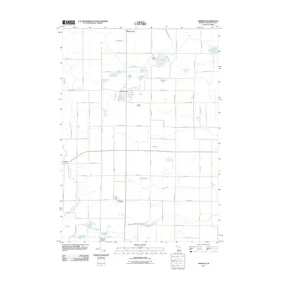
2011 Map of Sheridan
USGS Topo · Published 2011About this map
Sheridan serves as the central hub of this agricultural and lake-dotted region in Montcalm County, situated just north of Pearl Lake. The landscape is defined by a dense network of water bodies, including Mitchell Lake, Holland Lake, and the southern cluster of Horseshoe Lake and Snow Lake. To the south, the settlement of Fenwick is a key point of interest for local historians, featuring the Fenwick Post Office and providing a glimpse into the rural community's infrastructure. Small-scale aviation and recreation are represented by Minikey Airport and the Holland Lake Golf Course, while the northern reaches include the locality of Kings Corner. This 2011 survey captures the transition of the area as it maintains its rural character while supporting seasonal recreation at places like Snow Lake Kampground. Genealogists will find several burial grounds documented, such as Sheridan Cemetery and the uniquely labeled Clear Lake Cemetery Cemetery.
Find a feature on this map
53 named features on this map. Tap any name to fly to it.
Don’t see what you’re looking for? This feature index may not catch every label — zoom into the map to look around manually.
Map Details
Editions of this 2011 Sheridan Map
This is the sole edition of this map. No revisions or reprints were ever made.
Other maps of this area

1954 · Midland
USGS Topo · 1:250,000

1958 · Midland
USGS Topo · 1:250,000

1959 · Midland
USGS Topo · 1:250,000

1964 · Langston
USGS Topo · 1:24,000

1964 · Stanton
USGS Topo · 1:24,000

1965 · Crystal
USGS Topo · 1:24,000

1966 · Midland
USGS Topo · 1:250,000
1967 · Palo
USGS Topo · 1:24,000
1967 · Butternut
USGS Topo · 1:24,000
1972 · Belding
USGS Topo · 1:24,000