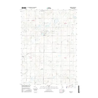
2017 Map of Sheridan
USGS Topo · Published 2017About this map
Sheridan serves as the central hub of this agricultural and wetland landscape in southern Montcalm County. The village is tightly clustered around the banks of Pearl Lake, while the surrounding townships are defined by a dense network of small glacial lakes and drainage systems like Baker Drain. The map reveals a deeply rooted rural community, marked by established burial grounds such as Evergreen Cem and Sheridan Cem.
Find a feature on this map
88 named features on this map. Tap any name to fly to it.
Don’t see what you’re looking for? This feature index may not catch every label — zoom into the map to look around manually.
Map Details
Editions of this 2017 Sheridan Map
This is the sole edition of this map. No revisions or reprints were ever made.
Other maps of this area

1954 · Midland
USGS Topo · 1:250,000

1958 · Midland
USGS Topo · 1:250,000

1959 · Midland
USGS Topo · 1:250,000

1964 · Langston
USGS Topo · 1:24,000

1964 · Stanton
USGS Topo · 1:24,000

1965 · Crystal
USGS Topo · 1:24,000

1966 · Midland
USGS Topo · 1:250,000
1967 · Palo
USGS Topo · 1:24,000
1967 · Butternut
USGS Topo · 1:24,000
1972 · Belding
USGS Topo · 1:24,000