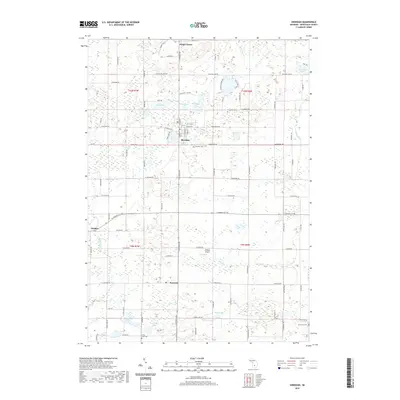
2019 Map of Sheridan
USGS Topo · Published 2019About this map
The village of Sheridan serves as the central hub of this Montcalm County landscape, where residential blocks give way to a dense network of glacial lakes and agricultural drainages. To the south, the settlement of Fenwick sits near the headwaters of Bacon Cr, while Amsden occupies the western edge along Dickerson Creek. The terrain is defined by its water bodies, ranging from the large Snow Lake and Clear Lake in the south to the clustered Pearl Lake, Mann Lake, and Hisington Lake near the town center. Local history is anchored by several burial grounds, including Evergreen Cem and Sunny Hill Cem, which mark the rural sections between active farmsteads. Transportation is facilitated by a grid of county roads like S Sheridan Rd, alongside the small Minikey Airport serving the local aviation needs of the community.
Find a feature on this map
88 named features on this map. Tap any name to fly to it.
Don’t see what you’re looking for? This feature index may not catch every label — zoom into the map to look around manually.
Map Details
Editions of this 2019 Sheridan Map
This is the sole edition of this map. No revisions or reprints were ever made.
Other maps of this area

1954 · Midland
USGS Topo · 1:250,000

1958 · Midland
USGS Topo · 1:250,000

1959 · Midland
USGS Topo · 1:250,000

1964 · Langston
USGS Topo · 1:24,000

1964 · Stanton
USGS Topo · 1:24,000

1965 · Crystal
USGS Topo · 1:24,000

1966 · Midland
USGS Topo · 1:250,000
1967 · Palo
USGS Topo · 1:24,000
1967 · Butternut
USGS Topo · 1:24,000
1972 · Belding
USGS Topo · 1:24,000