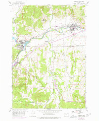
1956 Map of Sheridan
USGS Topo · Published 1978About this map
The South Fork Yamhill River valley serves as the central corridor for industry and settlement in this mid-century survey of the Oregon Coast Range foothills. The twin hubs of Sheridan and Willamina are joined by the Southern Pacific railroad, while the Longview Portland and Northern line extends southward to serve the timber and milling interests near the Millponds. The map captures a shifting educational landscape, noting active rural institutions like Rock Creek Sch and Mill Creek School alongside the already defunct Fendall Sch and Gooseneck Sch. To the north, the St Francis Xavier Novitiate occupies the higher ground above the river, while the southern portion of the quadrangle opens into the broad agricultural reaches of Red Prairie and the community of Buell.
Find a feature on this map
33 named features on this map. Tap any name to fly to it.
Don’t see what you’re looking for? This feature index may not catch every label — zoom into the map to look around manually.
Map Details
Editions of this 1956 Sheridan Map
4 editions found
Other maps of this area

1942 · Sheridan
USGS Topo · 1:62,500

1942 · Spirit Mtn
USGS Topo · 1:62,500

1942 · Valsetz
USGS Topo · 1:62,500

1942 · Dallas
USGS Topo · 1:62,500

1948 · Vancouver
USGS Topo · 1:250,000

1950 · Vancouver
USGS Topo · 1:250,000

1950 · Vancouver
USGS Topo · 1:250,000

1953 · Salem
USGS Topo · 1:250,000

1954 · Salem
USGS Topo · 1:250,000

1955 · Grand Ronde
USGS Topo · 1:62,500