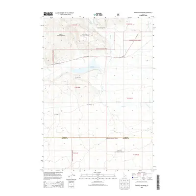
2013 Map of Sheridan Reservoir
USGS Topo · Published 2013About this map
The Centennial Mountains define the northern horizon of this landscape, where the Targhee National Forest straddles the high ground above the Upper Snake River Plain. Centered on Sheridan Reservoir, the topography transitions from the dramatic elevations of Sheridan Ridge down into the drainage basins of Sheridan Cr and Kick Cr. This 2013 survey illustrates a wilderness interface where forest service routes like Yale Kilgore Rd and Taylor Creek Rd provide access to the high backcountry. The map documents the boundary between Clark and Fremont counties, following the southern edge of the forest. The presence of Old Highway 22 tracing the lower elevations suggests earlier trans-mountain travel corridors that predated more modern alignments. The drainage network, including Mud Cr and E Fork Sheridan Cr, underscores the hydrologic importance of this watershed for the surrounding agricultural valleys.
Find a feature on this map
19 named features on this map. Tap any name to fly to it.
Don’t see what you’re looking for? This feature index may not catch every label — zoom into the map to look around manually.
Map Details
Editions of this 2013 Sheridan Reservoir Map
This is the sole edition of this map. No revisions or reprints were ever made.
Other maps of this area

1950 · Lower Red Rock Lake
USGS Topo · 1:62,500

1950 · Upper Red Rock Lake
USGS Topo · 1:62,500

1955 · Ashton
USGS Topo · 1:250,000

1958 · Ashton
USGS Topo · 1:250,000

1960 · Ashton
USGS Topo · 1:250,000
1965 · Icehouse Creek
USGS Topo · 1:24,000

1965 · Crystal Butte
USGS Topo · 1:24,000
1965 · Bishop Mountain
USGS Topo · 1:24,000

1965 · Sheridan Reservoir
USGS Topo · 1:24,000

1972 · Pine Butte
USGS Topo · 1:24,000