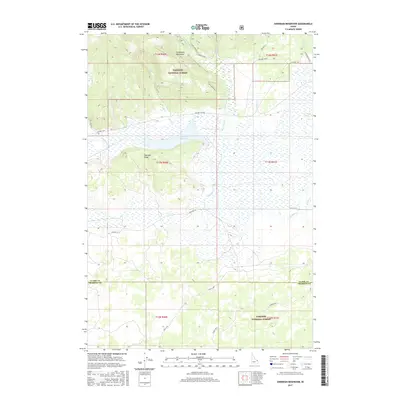
2017 Map of Sheridan Reservoir
USGS Topo · Published 2017About this map
Sheridan Reservoir and the surrounding high country of the Targhee National Forest dominate this high-altitude landscape along the Clark and Fremont County line. The terrain transitions from the steep southern slopes of the Centennial Mountains into a complex network of wetlands and drainage basins. High-elevation hydrology is well-defined here, with Sheridan Creek, Taylor Creek, and Howard Creek feeding the local basin.
Find a feature on this map
30 named features on this map. Tap any name to fly to it.
Don’t see what you’re looking for? This feature index may not catch every label — zoom into the map to look around manually.
Map Details
Editions of this 2017 Sheridan Reservoir Map
This is the sole edition of this map. No revisions or reprints were ever made.
Other maps of this area

1950 · Lower Red Rock Lake
USGS Topo · 1:62,500

1950 · Upper Red Rock Lake
USGS Topo · 1:62,500

1955 · Ashton
USGS Topo · 1:250,000

1958 · Ashton
USGS Topo · 1:250,000

1960 · Ashton
USGS Topo · 1:250,000
1965 · Icehouse Creek
USGS Topo · 1:24,000

1965 · Crystal Butte
USGS Topo · 1:24,000
1965 · Bishop Mountain
USGS Topo · 1:24,000

1965 · Sheridan Reservoir
USGS Topo · 1:24,000

1972 · Pine Butte
USGS Topo · 1:24,000