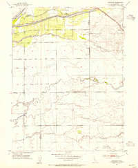
1953 Map of Sheridan
USGS Topo · Published 1954About this map
The Sheridan settlement serves as the primary rail hub on this mid-century survey, situated along the Southern Pacific tracks where the Central Valley begins to transition into the Sierra foothills. The landscape is defined by an intricate network of water management, with the Bear River forming a critical border in the north, flanked by levees and a Pump House. This hydrologic complexity continues southward through a series of natural and modified channels including Yankee Slough, Coon Creek, and Markham Ravine.
Find a feature on this map
21 named features on this map. Tap any name to fly to it.
Don’t see what you’re looking for? This feature index may not catch every label — zoom into the map to look around manually.
Map Details
Editions of this 1953 Sheridan Map
4 editions found
Other maps of this area

1888 · Marysville
USGS Topo · 1:125,000

1888 · Smartsville
USGS Topo · 1:125,000

1891 · Sacramento
USGS Topo · 1:125,000

1891 · Marysville
USGS Topo · 1:125,000

1891 · Smartsville
USGS Topo · 1:125,000

1892 · Sacramento
USGS Topo · 1:125,000

1892 · Smartsville
USGS Topo · 1:125,000

1893 · Sacramento
USGS Topo · 1:125,000

1894 · Smartsville
USGS Topo · 1:125,000

1894 · Marysville
USGS Topo · 1:125,000