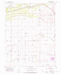
1953 Map of Sheridan
USGS Topo · Published 1976About this map
The Johnson Grant Rancho defines the northern landscape of this region, where the Bear River winds along the boundary shared by Sutter and Yuba counties. This mid-century survey illustrates an intricate hydrological network of sloughs and creeks, including Grasshopper Slough and Yankee Slough, which drain the low-lying agricultural lands. The settlement of Sheridan sits as a primary rail-side hub in the northeast, positioned along the Southern Pacific railroad line.
Find a feature on this map
19 named features on this map. Tap any name to fly to it.
Don’t see what you’re looking for? This feature index may not catch every label — zoom into the map to look around manually.
Map Details
Editions of this 1953 Sheridan Map
4 editions found
Other maps of this area

1888 · Marysville
USGS Topo · 1:125,000

1888 · Smartsville
USGS Topo · 1:125,000

1891 · Sacramento
USGS Topo · 1:125,000

1891 · Marysville
USGS Topo · 1:125,000

1891 · Smartsville
USGS Topo · 1:125,000

1892 · Sacramento
USGS Topo · 1:125,000

1892 · Smartsville
USGS Topo · 1:125,000

1893 · Sacramento
USGS Topo · 1:125,000

1894 · Smartsville
USGS Topo · 1:125,000

1894 · Marysville
USGS Topo · 1:125,000