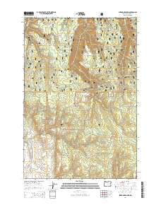
2014 Map of Sherod Meadows
USGS Topo · Published 2014About this map
Sherod Meadows sits within the protected landscape of the Wallowa National Forest, a region defined by its complex network of named ridges and mountain springs. The terrain is marked by significant topographical landmarks such as Powwatka Ridge, Washboard Ridge, and Deer Ridge, which dictate the drainage patterns of numerous small waterways. Of particular interest to those tracing the lore of the region are the many distinctively named water sources, including Yellow Jacket Spring, Fourth of July Spring, and Rockwall Spring. These labels, alongside creeks like Straight Whisky Cr, suggest a history of seasonal grazing or early forest service camps. The presence of routes like Tick Hill Rd and Troy Rd provides a look at the established access points through the forest during the early 21st century.
Find a feature on this map
37 named features on this map. Tap any name to fly to it.
Don’t see what you’re looking for? This feature index may not catch every label — zoom into the map to look around manually.
Map Details
Editions of this 2014 Sherod Meadows Map
This is the sole edition of this map. No revisions or reprints were ever made.
Other maps of this area

1955 · Grangeville
USGS Topo · 1:250,000

1957 · Sled Springs
USGS Topo · 1:62,500

1959 · Grangeville
USGS Topo · 1:250,000

1964 · Akers Butte
USGS Topo · 1:24,000

1964 · Wallowa
USGS Topo · 1:24,000

1967 · Wood Butte
USGS Topo · 1:24,000
1967 · Shamrock Creek
USGS Topo · 1:24,000

1967 · Promise
USGS Topo · 1:24,000

1982 · Wallowa
USGS Topo · 1:100,000
1984 · Akers Butte
USGS Topo · 1:24,000