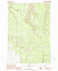
1990 Map of Sherod Meadows
USGS Topo · Published 1990About this map
Sherod Meadows sits at the heart of this high-altitude landscape within the Wallowa National Forest, where the terrain is defined by a series of prominent northern Oregon divides. The massive Powwatka Ridge dominates the central portion of the map, flanked by Tope Ridge and the heavily articulated slopes of Washboard Ridge. This 1990 survey captures the area’s dependence on natural water sources, identifying numerous named points such as Yellow Jacket Spring, Five Dollar Spring, and Fourth of July Spring. A critical navigational and historical landmark, the Lookout Tower Tope Creek, stands at an elevation of 4,720 feet, overlooking the deep drainage of Tope Creek. The map also traces the winding courses of Wildcat Creek, Straight Whisky Creek, and Alder Creek, illustrating a complex network of seasonal and perennial waterways that have shaped the land use and accessibility of this forested region.
Find a feature on this map
20 named features on this map. Tap any name to fly to it.
Don’t see what you’re looking for? This feature index may not catch every label — zoom into the map to look around manually.
Map Details
Editions of this 1990 Sherod Meadows Map
This is the sole edition of this map. No revisions or reprints were ever made.
Other maps of this area

1955 · Grangeville
USGS Topo · 1:250,000

1957 · Sled Springs
USGS Topo · 1:62,500

1959 · Grangeville
USGS Topo · 1:250,000

1964 · Akers Butte
USGS Topo · 1:24,000

1964 · Wallowa
USGS Topo · 1:24,000

1967 · Wood Butte
USGS Topo · 1:24,000
1967 · Shamrock Creek
USGS Topo · 1:24,000

1967 · Promise
USGS Topo · 1:24,000

1982 · Wallowa
USGS Topo · 1:100,000
1984 · Akers Butte
USGS Topo · 1:24,000