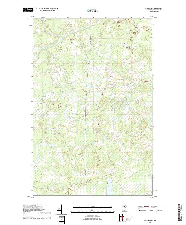
2022 Map of Sherry Lake
USGS Topo · Published 2022About this map
Sherry Lake sits at the southern edge of this north-woods landscape, which is defined by an extensive network of recreational and historic paths. The long corridor of the Taconite State Trl bisects the terrain, intersecting with several secondary routes including Link Lake Trl, Snake Trl, and Bear Lake Trl. These trails reflect the area's modern land use and its history of timber and resource access. The hydrology is dominated by wetlands and slow-moving water, with the Bear River flowing through the northern sections and Venning Cr winding toward Wamp Lake. Smaller features like Stingy Brook and Little Moose Trl provide further detail for those tracing specific land parcels or exploring the remote corners of these northern townships.
Find a feature on this map
18 named features on this map. Tap any name to fly to it.
Don’t see what you’re looking for? This feature index may not catch every label — zoom into the map to look around manually.
Map Details
Editions of this 2022 Sherry Lake Map
This is the sole edition of this map. No revisions or reprints were ever made.
Other maps of this area

1919 · Release
USGS Topo · 1:62,500

1943 · Release
USGS Topo · 1:62,500

1954 · Hibbing
USGS Topo · 1:250,000

1957 · Hibbing
USGS Topo · 1:250,000

1958 · Hibbing
USGS Topo · 1:250,000

1964 · Hibbing
USGS Topo · 1:250,000

1964 · Side Lake
USGS Topo · 1:24,000
1964 · Stingy Lake
USGS Topo · 1:24,000

1964 · Sherry Lake
USGS Topo · 1:24,000
1964 · O'Leary Lake
USGS Topo · 1:24,000