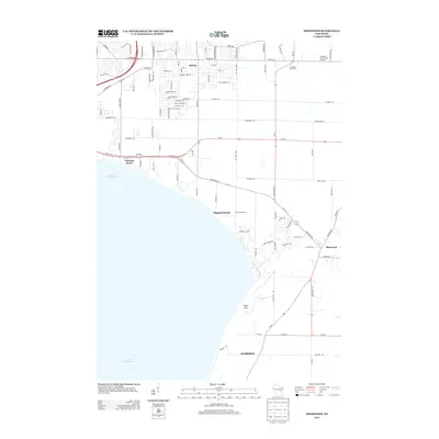
2013 Map of Sherwood
USGS Topo · Published 2013About this map
Lake Winnebago defines the southwestern portion of this landscape, its expansive shoreline dotted with lakeside settlements and beach communities. The residential growth extending south from Appleton is evident in Darboy, where a dense network of suburban streets like Amy Ave and Colin St contrasts with the agricultural character of the eastern terrain. Inland, the map reveals the persistent dairy heritage of the region through the Triangle Dairy Farm and Ameri-Milk Farm.
Find a feature on this map
102 named features on this map. Tap any name to fly to it.
Don’t see what you’re looking for? This feature index may not catch every label — zoom into the map to look around manually.
Map Details
Editions of this 2013 Sherwood Map
This is the sole edition of this map. No revisions or reprints were ever made.
Other maps of this area

1911 · Neenah
USGS Topo · 1:62,500

1954 · De Pere
USGS Topo · 1:62,500

1954 · Chilton
USGS Topo · 1:62,500

1955 · Neenah
USGS Topo · 1:62,500

1955 · Appleton
USGS Topo · 1:24,000

1955 · Appleton
USGS Topo · 1:62,500

1955 · Neenah
USGS Topo · 1:24,000

1955 · Green Bay
USGS Topo · 1:250,000

1974 · Hilbert
USGS Topo · 1:24,000
1974 · Chilton
USGS Topo · 1:24,000