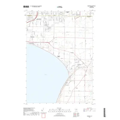
2018 Map of Sherwood
USGS Topo · Published 2018About this map
Lake Winnebago defines the western edge of this Calumet County region, where the shoreline transitions from the developed residential pockets of Utowana Beach and Highland Beach to the protected landscape of High Cliff park. The map illustrates the suburban expansion pushing south from Appleton and Kaukauna into traditionally rural townships. Evidence of the area's long-settled heritage is found in the scattered burial grounds, including the High Cliff Cem and the Mansfield Family Cem further south. The eastern portion of the quadrangle shows the winding course of the Killsnake River as it moves through a more open, agricultural terrain, contrasting with the dense street grids appearing near Darboy and Combined Locks.
Find a feature on this map
125 named features on this map. Tap any name to fly to it.
Don’t see what you’re looking for? This feature index may not catch every label — zoom into the map to look around manually.
Map Details
Editions of this 2018 Sherwood Map
This is the sole edition of this map. No revisions or reprints were ever made.
Other maps of this area

1911 · Neenah
USGS Topo · 1:62,500

1954 · De Pere
USGS Topo · 1:62,500

1954 · Chilton
USGS Topo · 1:62,500

1955 · Neenah
USGS Topo · 1:62,500

1955 · Appleton
USGS Topo · 1:24,000

1955 · Appleton
USGS Topo · 1:62,500

1955 · Neenah
USGS Topo · 1:24,000

1955 · Green Bay
USGS Topo · 1:250,000

1974 · Hilbert
USGS Topo · 1:24,000
1974 · Chilton
USGS Topo · 1:24,000