
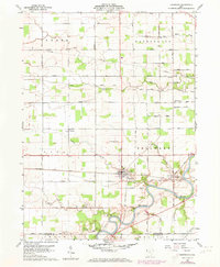
1960 Map of Sherwood
USGS Topo · Published 1961About this map
Sherwood serves as the primary hub of this 1960 landscape, situated at the intersection of the Baltimore and Ohio and New York Central railroads. The town's grid is bounded by Fountain Street and the rail corridors, illustrating a mid-century community built on transportation and trade. To the southeast, the Maumee River snakes through the terrain, its course followed by several family-named landmarks and rural routes like Sausman Road.
Find a feature on this map
52 named features on this map. Tap any name to fly to it.
Don’t see what you’re looking for? This feature index may not catch every label — zoom into the map to look around manually.
Map Details
Editions of this 1960 Sherwood Map
2 editions found
Other maps of this area

1907 · Defiance
USGS Topo · 1:62,500

1909 · Defiance
USGS Topo · 1:62,500

1909 · Continental
USGS Topo · 1:62,500

1914 · Bryan
USGS Topo · 1:62,500

1914 · Paulding
USGS Topo · 1:62,500

1943 · Bryan
USGS Topo · 1:62,500

1944 · Paulding
USGS Topo · 1:62,500

1953 · Fort Wayne
USGS Topo · 1:250,000

1956 · Fort Wayne
USGS Topo · 1:250,000
1960 · Defiance West
USGS Topo · 1:24,000