
1938 Map of Sherwood
USGS Topo · Published 1956About this map
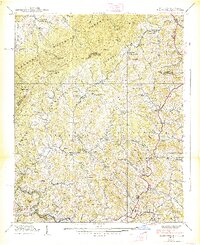
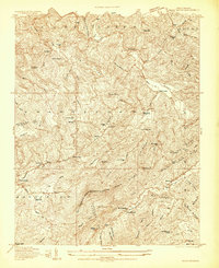
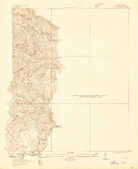
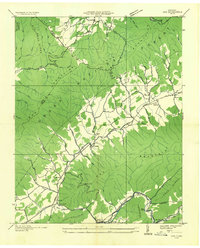
Sherwood and the surrounding high-country settlements of Watauga River valley are caught in a moment of transition during this 1930s survey. The landscape is defined by its social infrastructure of small churches and schools, such as Beaverdam Ch and Cove Creek Sch, which anchored the rural communities before mid-century consolidation. The boundary between the Cherokee National Forest and Pisgah National Forest runs through these ridges, marking a territory where timber interests and federal management intersected with long-established family homesteads. The map shows a network of creeks and hollows, from Beaverdam Creek to Snake Den Creek, that dictated the placement of mountain roads and early crossings like the Green Bridge. This topography reveals the deep-seated reliance on water gaps for travel, seen at George Gap and Ward Gap, which served as vital conduits through the steep terrain.
Find a feature on this map
81 named features on this map. Tap any name to fly to it.
Don’t see what you’re looking for? This feature index may not catch every label — zoom into the map to look around manually.
Map Details
Editions of this 1938 Sherwood Map
5 editions found
Other maps of this area

1893 · Cranberry
USGS Topo · 1:125,000

1895 · Cranberry
USGS Topo · 1:125,000

1899 · Cranberry
USGS Topo · 1:125,000

1902 · Cranberry
USGS Topo · 1:125,000
1934 · Valle Crucis
USGS Topo · 1:24,000

1934 · Elk Park
USGS Topo · 1:24,000
1934 · Boone
USGS Topo · 1:24,000
1935 · Doe
USGS Topo · 1:24,000

1935 · Baldwin Gap
USGS Topo · 1:24,000

1935 · Doe Mountain
USGS Topo · 1:48,000