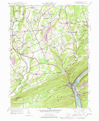
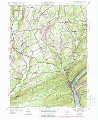
1954 Map of Shickshinny
USGS Topo · Published 1978About this map
Shickshinny and Mocanaqua anchor the southeastern corner of this landscape, situated along the banks of the Susquehanna River where the waterway cuts through Shickshinny Mountain. The topography is defined by the parallel ridges of Huntingdon and Shickshinny, which hem in the drainage basins of Huntington Creek and Shickshinny Creek. These valleys are dotted with small agricultural and milling settlements like Huntington Mills and Harveyville, many of which grew around early water power sites.
Find a feature on this map
56 named features on this map. Tap any name to fly to it.
Don’t see what you’re looking for? This feature index may not catch every label — zoom into the map to look around manually.
Map Details
Editions of this 1954 Shickshinny Map
5 editions found
Other maps of this area

1891 · Harveys Lake
USGS Topo · 1:62,500

1893 · Harvey Lake
USGS Topo · 1:62,500

1894 · Shickshinny
USGS Topo · 1:62,500

1894 · Bloomsburg
USGS Topo · 1:62,500

1934 · Laporte
USGS Topo · 1:62,500

1946 · Sybertsville
USGS Topo · 1:31,680

1946 · Nanticoke
USGS Topo · 1:31,680

1946 · Shickshinny
USGS Topo · 1:31,680

1946 · Berwick
USGS Topo · 1:31,680

1946 · Harveys Lake
USGS Topo · 1:24,000
Featured Places
- Hunlock Township, PA
- Conyngham Township, PA
- Shickshinny, PA
- Briar Creek Township, PA
- Muhlenburg, Union Township