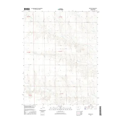
2015 Map of Shields SE
USGS Topo · Published 2015About this map
The High Plains of western Kansas are defined here by a series of parallel drainage systems, including the N Fork Walnut Cr and Middle Fork Walnut Cr. These waterways cut through the flat agricultural landscape of Lane County, creating subtle topographic variation in an area dominated by large-scale section-line farming. The grid-based road network, including uniquely named routes like Turkey Red and Rowdy Rd, underscores the rigid Public Land Survey System that organized this territory into townships such as t17s r27w. While the terrain appears uniform at a distance, the map reveals the intricate dendritic patterns of Cottonwood Cr and Wild Horse Cr, which serve as the primary natural landmarks in this rural expanse. This 2015 edition provides a precise view of the modern rural infrastructure and land management patterns common to the Kansas wheat belt.
Find a feature on this map
24 named features on this map. Tap any name to fly to it.
Don’t see what you’re looking for? This feature index may not catch every label — zoom into the map to look around manually.
Map Details
Editions of this 2015 Shields SE Map
This is the sole edition of this map. No revisions or reprints were ever made.
Other maps of this area

1955 · Scott City
USGS Topo · 1:250,000

1958 · Scott City
USGS Topo · 1:250,000

1965 · Beeler
USGS Topo · 1:24,000

1965 · Utica SW
USGS Topo · 1:24,000

1974 · Dighton
USGS Topo · 1:24,000

1974 · Alamota
USGS Topo · 1:24,000

1974 · Shields NW
USGS Topo · 1:24,000

1974 · Pendennis
USGS Topo · 1:24,000

1974 · Shields SE
USGS Topo · 1:24,000
1974 · Shields
USGS Topo · 1:24,000