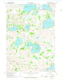
1960 Map of Shieldsville
USGS Topo · Published 1974About this map
Shieldsville stands as a central point of this Rice County landscape, surrounded by an intricate network of glacial lakes including Shields Lake, French Lake, and the expansive Cedar Lake. The map illustrates a rural society organized around small school districts and family landmarks, with Trebon Sch and its adjacent Trebon Cem appearing in the northwest, while North Cedar Lake Sch and Lake View Sch serve the lakeside communities. To the south, the settlement of Warsaw is positioned along the Cannon River and the C & N W railroad line. The presence of numerous Gravel Pits and a Townhall indicates the local infrastructure and industry of the mid-century era. This survey also records smaller water bodies like Willing Lake and Weinberger Lake, reflecting the well-watered topography of the Shieldsville and Morristown townships.
Find a feature on this map
33 named features on this map. Tap any name to fly to it.
Don’t see what you’re looking for? This feature index may not catch every label — zoom into the map to look around manually.
Map Details
Editions of this 1960 Shieldsville Map
4 editions found
Other maps of this area

1953 · Saint Paul
USGS Topo · 1:250,000

1959 · Saint Paul
USGS Topo · 1:250,000

1960 · Faribault
USGS Topo · 1:24,000

1960 · Shieldsville
USGS Topo · 1:24,000

1960 · Lonsdale
USGS Topo · 1:24,000

1960 · Little Chicago
USGS Topo · 1:24,000

1962 · Morristown
USGS Topo · 1:24,000

1962 · Medford West
USGS Topo · 1:24,000

1966 · Montgomery
USGS Topo · 1:24,000

1966 · Waterville
USGS Topo · 1:24,000