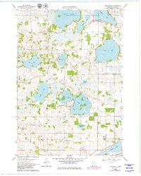
1960 Map of Shieldsville
USGS Topo · Published 1979About this map
Shieldsville and Warsaw anchor this map of the lake-strewn landscape in Rice County, where the Cannon River weaves through a complex network of glacial basins. The 1960 field survey reveals a settled agricultural and recreational district characterized by an unusually high density of rural schoolhouses and neighborhood landmarks. Genealogists will find the Trebon Cem and Trebon Sch in the northwest, while the southern reaches near the C & G W railroad tracks include the Trinity Sch and Kennyville Sch. The interior is dominated by large water bodies such as French Lake and Cedar Lake, many of which are buffered by localized wetlands and marshes. This landscape reflects the mid-century transition of central Minnesota, where traditional townships like Erin, Wells, and Morristown maintained distinct rural identities through their local Townhall and school sites before late-century consolidation.
Find a feature on this map
33 named features on this map. Tap any name to fly to it.
Don’t see what you’re looking for? This feature index may not catch every label — zoom into the map to look around manually.
Map Details
Editions of this 1960 Shieldsville Map
4 editions found
Other maps of this area

1953 · Saint Paul
USGS Topo · 1:250,000

1959 · Saint Paul
USGS Topo · 1:250,000

1960 · Faribault
USGS Topo · 1:24,000

1960 · Shieldsville
USGS Topo · 1:24,000

1960 · Lonsdale
USGS Topo · 1:24,000

1960 · Little Chicago
USGS Topo · 1:24,000

1962 · Morristown
USGS Topo · 1:24,000

1962 · Medford West
USGS Topo · 1:24,000

1966 · Montgomery
USGS Topo · 1:24,000

1966 · Waterville
USGS Topo · 1:24,000