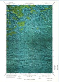
1974 Map of Shilling Dam
USGS Topo · Published 1976About this map
Beltrami Island State Forest defines the northern reaches of Minnesota in this mid-1970s orthophotomap, showing a landscape shaped by vast conservation tracts and indigenous lands. The northern boundary of the Red Lake Indian Reservation meets the Lake of the Woods Co line, where the Rapid River winds through the dense vegetation. The imagery highlights the essential infrastructure of this wilderness, from the namesake Shilling Dam to a remote Winter Trail cutting through the forest. Land use is largely dedicated to the Red Lake State Wildlife Management Area, with small-scale industrial marks like a Gravel Pit providing the only evidence of human engineering in an otherwise protected natural corridor. The orthophoto format provides researchers with a literal view of forest density and water patterns that traditional topographic lines cannot fully convey.
Find a feature on this map
9 named features on this map. Tap any name to fly to it.
Don’t see what you’re looking for? This feature index may not catch every label — zoom into the map to look around manually.
Map Details
Editions of this 1974 Shilling Dam Map
This is the sole edition of this map. No revisions or reprints were ever made.
Other maps of this area

1918 · F
USGS Topo · 1:62,500

1919 · G
USGS Topo · 1:62,500

1919 · Ponemah
USGS Topo · 1:62,500

1943 · Ponemah
USGS Topo · 1:62,500

1954 · Roseau
USGS Topo · 1:250,000

1957 · Roseau
USGS Topo · 1:250,000

1958 · Roseau
USGS Topo · 1:250,000

1973 · Manomin Creek
USGS Topo · 1:24,000

1973 · Thorhult
USGS Topo · 1:24,000
1973 · Shilling Dam NW
USGS Topo · 1:24,000