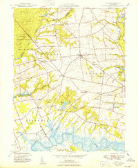
1949 Map of Shiloh
USGS Topo · Published 1949About this map
Agricultural life and tidal waterways dominate this corner of Cumberland County, where the Cohansey River winds through the south, feeding into a network of marshes and drainage ditches. The landscape is dotted with small agrarian settlements like Shiloh, Roadstown, and Marlboro, connected by a grid of rural roads and the tracks of the Central RR of New Jersey. The importance of local industry is evident in the multiple historic mill sites, including Mickles Mill and Seventh Day Mill, which utilized the area's numerous runs and creeks. Near the river, maritime activity is anchored by Greenwich Pier and Laning Wharf, while the interior shows established civic infrastructure such as the County Almshouse and County Hospital. This survey documents a transition in land use, showing the early infrastructure of the Cranberry bog and the organized drainage of Raccoon Ditch alongside traditional family-named crossroads.
Find a feature on this map
75 named features on this map. Tap any name to fly to it.
Don’t see what you’re looking for? This feature index may not catch every label — zoom into the map to look around manually.
Map Details
Editions of this 1949 Shiloh Map
2 editions found
Other maps of this area

1890 · Salem
USGS Topo · 1:62,500

1890 · Bay Side
USGS Topo · 1:62,500

1890 · Bridgeton
USGS Topo · 1:62,500

1890 · Glassboro
USGS Topo · 1:62,500

1894 · Bay Side
USGS Topo · 1:62,500

1894 · Bridgeton
USGS Topo · 1:62,500

1898 · Salem
USGS Topo · 1:62,500

1898 · Glassboro
USGS Topo · 1:62,500

1899 · Vineland
USGS Topo · 1:125,000

1901 · Camden
USGS Topo · 1:125,000
Featured Places
- Bridgeton, NJ
- Fairfield Township, NJ
- Hopewell Township, NJ
- Quinton Township, NJ
- Lower Alloways Creek Township, NJ