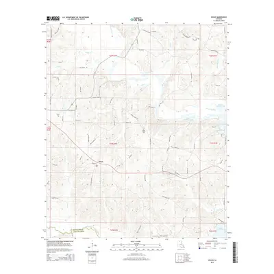
2015 Map of Shiloh
USGS Topo · Published 2015About this map
Shiloh and Evergreen anchor this rural landscape in north-central Louisiana, where the terrain is defined by the winding tributaries of the D'Arbonne basin. The map detail highlights several historic burying grounds, including Shiloh Cem, Mount Patrick Cem, and Barrett Cem, which provide essential points of reference for local family history. A complex network of watercourses, such as Corney Bayou, Potter Cr, and the Middle Fork Bayou D'Arbonne, drains toward the expansive Bayou D'Arbonne Lake in the east. Numerous family-named roads, including Clayton Foster Rd and George Johnikins Rd, suggest a long-established pattern of local land ownership. Traces of historical river crossings are still evident in the naming of Lowery Ferry Rd, marking a time when travel relied on water-level transit before modern infrastructure spanned the bayous.
Find a feature on this map
78 named features on this map. Tap any name to fly to it.
Don’t see what you’re looking for? This feature index may not catch every label — zoom into the map to look around manually.
Map Details
Editions of this 2015 Shiloh Map
This is the sole edition of this map. No revisions or reprints were ever made.
Other maps of this area

1950 · Ruston
USGS Topo · 1:62,500

1951 · Ruston
USGS Topo · 1:62,500

1951 · Bernice
USGS Topo · 1:62,500

1952 · Calhoun
USGS Topo · 1:62,500

1952 · Farmerville
USGS Topo · 1:62,500

1955 · Shreveport
USGS Topo · 1:250,000

1956 · Shreveport
USGS Topo · 1:250,000
1982 · Downsville North
USGS Topo · 1:24,000

1984 · Shreveport
USGS Topo · 1:250,000

1985 · Monroe North
USGS Topo · 1:100,000