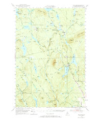
1954 Map of Shin Pond
USGS Topo · Published 1967About this map
The Seboeis River system defines this mid-century landscape in the north woods of Penobscot County, where timber and sporting traditions converge. Tracing the river's course reveals a series of water features and falls, including Shin Falls and the significant Sawtelle Falls. The map documents a rugged wilderness infrastructure dependent on water and primitive transport, evidenced by the numerous deadwaters like Hobart Deadwater and the network of logging routes such as the Matagamon Tote Road. Settlement is sparse and primarily seasonal or resource-focused, featuring several notable sporting and utility outposts. These include the Seboeis Fish and Game Club Camps, Bowlin Camps, and Seboeis Farm. The terrain is marked by prominent peaks such as Mount Chase and Snowshoe Mtn, while the southern portion of the sheet reaches the township of Patten, showing the transition from deep forest to the outskirts of more established rural life.
Find a feature on this map
118 named features on this map. Tap any name to fly to it.
Don’t see what you’re looking for? This feature index may not catch every label — zoom into the map to look around manually.
Map Details
Editions of this 1954 Shin Pond Map
4 editions found

Other maps of this area

1927 · Katahdin
USGS Topo · 1:48,000

1930 · Katahdin
USGS Topo · 1:62,500

1940 · Island Falls
USGS Topo · 1:62,500

1940 · Sherman
USGS Topo · 1:62,500

1940 · Oxbow
USGS Topo · 1:62,500

1942 · Island Falls
USGS Topo · 1:62,500

1942 · Oxbow
USGS Topo · 1:62,500

1942 · Sherman
USGS Topo · 1:62,500

1949 · Katahdin
USGS Topo · 1:62,500

1953 · Stacyville
USGS Topo · 1:62,500